
In Part One of this series of posts, I left you with the animation above, showing how our view of the Moon shifts subtly during the course of a month. Part One explained why this happens, so you might want to look at that before you continue here.
As I described last time, what’s going on in the animation (prepared, as ever, using Celestia) is that the Moon is librating in longitude (that is, east-west) by up to eight degrees, while librating in latitude (north-south) by close to seven degrees. The two periods of oscillation are not identical, so the wobble during the course of a month is not quite repeated in the following month—it takes six years to return to (approximately) the same pattern of oscillation.
And this shimmying around has implications for what the Earth looks like in the Moon’s sky. It doesn’t hang immobile over the lunar surface, as is often suggested in popular science and science fiction writing, but oscillates slowly around a mean position, moving up to eight degrees either side of that central point on an east-west axis, and almost seven degrees either side of it on a north-south axis.
I’ve used Celestia to assemble an animation of all this, adding some captions to explain what’s going on:
And all that movement means that there’s a fairly wide area of the Moon’s surface on which the Earth can be seen to rise and set, once a month. Here’s a view from the Moon’s south pole, speeded up a million times to fit a year into thirty seconds:
This also means that the point on the Moon’s surface at which the Earth is directly overhead (the sub-Earth point) roams quite widely, making a tour of several hundred kilometres every month, at a slow walking pace. Here’s six years’ worth of its travels across the centre of the Moon’s Earth-facing hemisphere, around a region appropriate called the Sinus Medii (“Central Bay”):

(Moon LRO LROC WAC Global Morphology Mosaic 100m)
The centre of this pattern defines the zero points of lunar latitude and longitude—it’s the average sub-Earth point, even though the Earth is almost never directly overhead there.
For scale and context, here’s the same track superimposed on the disc of the full Moon at mean libration—that is, centred at zero latitude and longitude:

(Moon LRO LROC WAC Global Morphology Mosaic 100m)
Any location within that red rectangle of sub-Earth points will, at some time, have the Earth directly overhead; and will, therefore, be momentarily at the centre of the Moon’s disc as seen from Earth. Around the rim of the Moon, I’ve shaded what I’ll call the libration zone in pale orange. This is the part of the Moon’s surface that will tilt in and out of view as the Moon librates (and where the Earth will be seen to rise and set each month). It looks tiny, doesn’t it? But that’s because we always see it at a very oblique angle. We can get a truer impression of its extent by using a different map projection, which preserves areas at the expense of distorting shapes. Here’s the Moon flattened out in a Lambert equal area projection:

(Moon LRO LROC WAC Global Morphology Mosaic 100m)
The entire near side is contained within the red circle, which marks the 90° east and west meridians. Now you can also see the parts of the far side which tilt into view as the Moon librates, and from which some future astronaut might therefore be able to catch a monthly glimpse of the Earth. (I’ve trimmed off most of the far side beyond the libration zone—it would be grossly distorted in this projection.)
Overall, the libration zone covers about 18% of the Moon’s surface, or just under seven million square kilometres.
The detail at the north and south poles is difficult to make out in this sort of global photomosaic, because the shadows are always long at the lunar poles. So I had a bit of fun preparing polar shaded relief maps from elevation data—the apparent illumination shown below is impossible on the real Moon. Here’s the north pole:
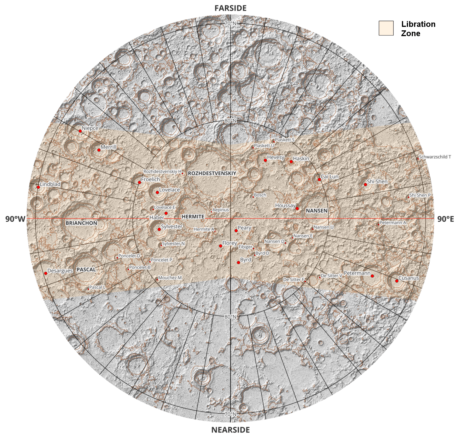
(Prepared using Moon LRO LOLA Digital Elevation Model 118m)
And the south:

(Prepared using Moon LRO LOLA Digital Elevation Model 118m)
Let’s go back to a more conventional view of the Moon, now. Here’s the lunar disc as we’d see it when the sub-Earth point is at its farthest excursion to the southwest:

(Moon LRO LROC WAC Global Morphology Mosaic 100m)
The libration zone has disappeared in the northeast, but we now have a better view of the near side libration zone in the southwest, as well as a glimpse into the far side libration zone.
Let’s zoom in. Here’s the view of the southwest lunar disc at mean libration:

(Moon LRO LROC WAC Global Morphology Mosaic 100m)
A couple of mountain ranges are just visible at the edge of the disc—the Montes Rook and Montes Cordillera. Now here’s the view of the same area under the most favourable libration conditions:

(Moon LRO LROC WAC Global Morphology Mosaic 100m)
A grey lava plain on the lunar far side is just peeping into view! Despite its location beyond 90° west lunar longitude, it’s called Mare Orientale, the Eastern Sea, because it’s on the eastern side of the lunar disc as viewed from Earth. It was named in 1906 by Julius Franz, using photographs taken by Edward Holden at the Lick Observatory during the 1890s.
Until the second half of the twentieth century, our only glimpse of the lunar far side was courtesy of these lunar librations; which also, as you can see, improved our view of the extreme margins of the near side. But not only did we need to wait for a favourable libration (which might take six years to recur), we also needed to wait for favourable lighting conditions during the libration—preferably low sunlight to emphasize topography.
I’ve already mentioned that libration in latitude and longitude have different periods of oscillation, and now we need to introduce a third out-of-synch oscillation—the illumination cycle, corresponding to the phases of the Moon. Below, I’ve plotted some sine waves, reflecting these three cycles during the course of a year:
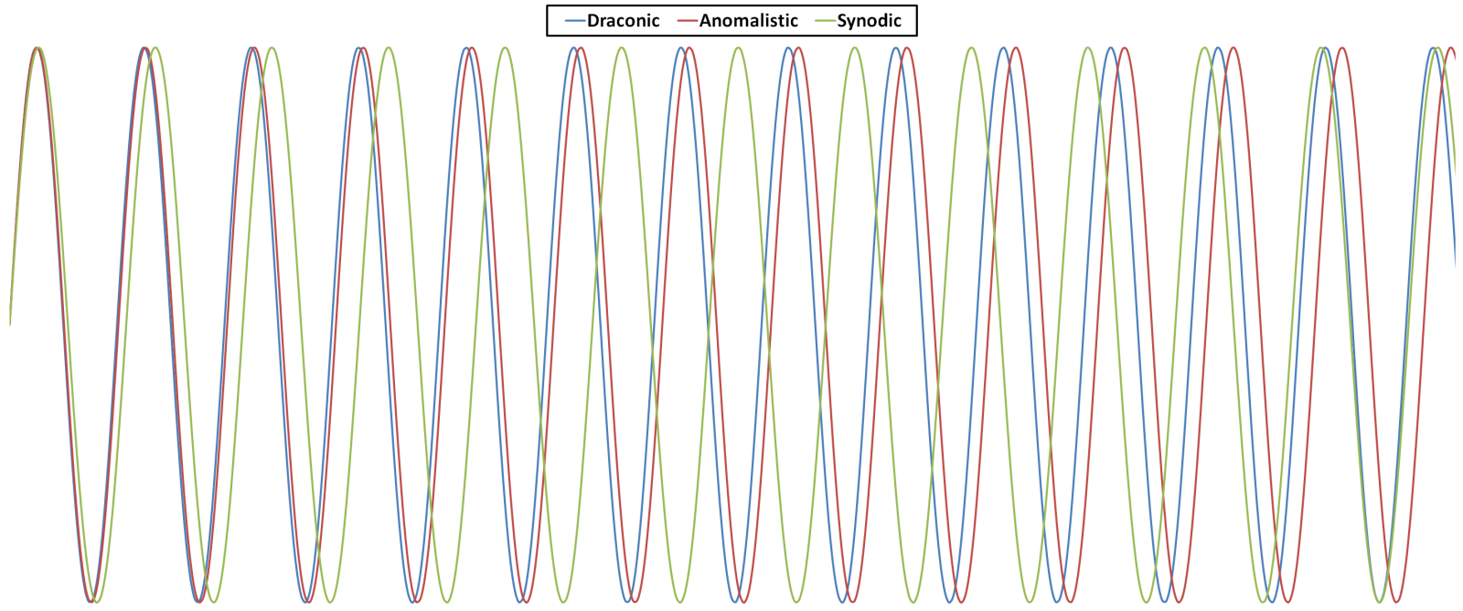
All the cycles are synchronized at the start of the year. In blue is the draconic month, of 27.2122 days, reflecting the length of a cycle of latitude libration. In red is the anomalistic month (27.5545 days) of longitude libration. As previously described, these are slowly diverging and won’t align again for six years. But in green is the synodic* month, the lunar illumination cycle (29.5305 days), which very quickly gets out of phase with the other cycles, but then comes back towards alignment in the course of a year.
All this means that there is at best just one night a year during which a favourable libration is combined with favourable illumination. During the first half of the twentieth century, astronomers (many of them amateurs) would wait with fingers crossed for a clear night on one of these rare occasions, during which they might glimpse and map some new feature of the lunar far side.
On 8 November 1965, for instance, a group of British amateurs took advantage of a favourable libration to observe the crater Caramuel† (now officially known as Einstein). Photographs were taken, but sketches made by skilled observers could often capture more detail, taking advantage of moments of excellent seeing. Below are a photograph, a sketch, and a rectified sketch by David A. Allen—the latter being a revision of the original sketch to simulate a view from directly overhead.

Photograph and sketches from Journal of the British Astronomical Association (1966) 76: 248-255
Professional astronomers, meanwhile, had come up with a neat trick to produce photographs of libration zone features as if viewed from overhead. They projected photographs of the Moon on to a white sphere, which they then photographed from the side. A compilation of these images was used in the creation of the Rectified Lunar Atlas (1963).

But this was the last gasp of Earth-based Moon mapping. The Lunar Orbiter missions commenced in 1963, with the aim of mapping the Moon photographically in preparation for a manned landing. The first three missions concentrated on potential landing sites, but Lunar Orbiter 4 had a more general mapping remit. And here’s its view of Caramuel / Einstein, obtained in 1967:‡

I’m going to visit this topic one more time, when I’ll write about the photographs of the Earth that the Apollo astronauts took from the surface of the Moon.
* Some day I’ll write a post explaining the strange names of the various kinds of month.
† This name was bestowed by amateur observer H. Percy Wilkins, who had mapped the crater during the 1950s. The name honoured the philosopher and mathematician Juan Caramuel y Lobkowitz, Bishop of Vigevano.
‡ The sketches and photographs all have north at the bottom, as was customary at the time, because observers were using astronomical telescopes with inverting lens systems.
or