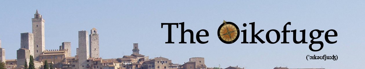
Beinn Mheadhonach (NN 880758, 901m)
23 kilometres
950 metres ascent

Contains OS OpenData © Crown copyright and database right 2018
Path data © OpenStreetMap contributors under the Open Database Licence
So, a bit of a change from the micro-level route-finding that’s been preoccupying me in the Sidlaws. This one’s a big, striding hill, tucked up the back of Blair Atholl, in that rather nebulous region referred to as “the Grampians”. The name of the hill is pronounced viˈɑnəx, Gaelic for “middle”. In hillwalking terms, it’s in the middle between two Munros, Beinn Dearg and Carn a’ Chlamain; geographically it’s in the middle between two glens, Gleann Diridh and Gleann Mhairc.
I walked up Glen Tilt, starting in the car park at Old Bridge of Tilt (NN 874662). Straight across the road and through a gateway takes you on to the main drag up the west side of the glen—a wide forest track with the River Tilt rushing through its steep-sided glen on the right.
On the map, it looks like you could stay on the west side of the Tilt all the way up to Glen Mhairc, but that would get you in amongst the Danger Area marked around the Croft Crombie rifle range. I’ve no idea how well that might go, and don’t intend finding out. So I crossed the Tilt on the Cumhann-leum Bridge. The name means “narrow leap”—the river didn’t look quite narrow enough for a running jump at the bridge crossing, but there’s presumably a narrow spot nearby.

Then, safely past the rifle range, I crossed back across the Tilt at Gilbert’s Bridge (the Ordnance Survey omits the apostrophe, but the bridge is named with the possessive both as a Listed Building and on the ScotlandsPlaces geographical database). So far, I’ve had no luck finding out who Gilbert was, but he must have lived a long time ago—Historic Environment Scotland dates the bridge to 1759, so it’s older than a lot of countries.
 From here, the way north is through an odd little gate that looks like something out of a low-budget 1970s science fiction TV series. A little way beyond that, you can save a bit of up-and-down by dropping off the main forest track on to a path that branches eastwards at NN 880701 and rejoins the main track at NN 883707. It takes you through clear-felled forestry on the flat-lands next to the Tilt, but you exchange easy walking on the up-and-down for tussocky, boggy stuff underfoot. You also pass below the ruined settlement of Ach Mhairc Bhig, of which more later.
 Next, there’s lovely open woodland and sheep-mown grass, taking you down to the Allt Mhairc and the Ach-mhairc bridge. Uphill to the left are more ruins, the abandoned settlement of Sean-bhaile, which means “old town”. And across the river are more tumbled stone walls, Ach Mhairc Mhoir. Ach is a shortened form of achadh, a field or enclosure. So it looks like we have the old settlement of Sean-bhaile flanked by two enclosure systems, the small one at Ach Mhairc Bhig, and the large one at Ach Mhairc Mhoir (beag and mor being “small” and “great”, respectively). There were houses at all three locations.

The Canmore archaeological reference website has this to say about Ach Mhairc Mhoir and Sean-bhaile:
At NN 8866 7125 is the depopulated settlement of Ach’ Mhaire [sic] Mhoir, comprising twenty-seven buildings, four corn-drying kilns and several enclosures within an area of lazy-bed cultivation and clearance heaps. The remains vary from grass covered footings 0.5m high to drystone walls 1.5m high suggesting two phases of depopulation, the first beginning about 1850.
 It’s from here that you get your first glimpse of Beinn Mheadhonach, as you walk north across rough pasture-land towards something marked on the map as the “New Bridge”. Given the age of Gilbert’s Bridge, “new” is a relative term, here—I find it marked on the 1867 Ordnance Survey six-inch map. There are trees growing out of its parapets. It’s not clear what it was used for. It obviously served the Sean-bhaile settlements, but even on the 1867 map, the track stops at the bridge—there’s no continuation on the far side of the river. I wonder if it was a way of getting animals safely across to graze on the slopes of Beinn Mheadhonach, which is otherwise moated in on either side by two rivers. But I’m open to suggestions or further information.

From the bridge, there’s a path all the way to the top, braiding here and there into multiple slots in the heather. The path I followed didn’t correspond to the zigzag marked on the OS 1:25,000. Higher up, at NN 878738, there’s a fork to the right that takes you around to the east side of the ridge. I found a nice cairn and shelter along there, but couldn’t quite figure out where the path was going, so struck off up-slope to rejoin the ridge-line path. A little cairn marks the summit, which is actually at NN 879754.
 The OS marks a 901m spot height at the north end of the summit ridge at NN 880758, and those are the summit coordinates given by the Scottish Mountaineering Club (I’ve also used them at the head of this post), but on the ground it’s obvious that the southern end of the ridge is a couple of metres higher.

But I wandered over to the 901m point for the sake of the view down into the remote head-waters of the Tarf. (And, well, you know, just to be sure I was at the top.)

It was at this point that I realized that I hadn’t had anything to eat or drink during the three hours it had taken me to walk this far. Indeed, I hadn’t had anything to eat since the previous evening. I’d climbed the hill on a seventeen-hour fast. I mention this not because I think it’s remarkable or impressive (impressively disorganized on my part, I suppose). In fact, it used to be pretty commonplace—Tom Weir‘s book Highland Days is full of accounts of epic, multi-Munro days during the 1930s, pulled off while provisioned with water from the burns and a slice of bread he happened to have in his pocket. Nowadays, though, I seem to keep meeting people who think they’ll probably just die on the hills if they don’t have a constant supply of water, electrolytes and low-glycaemic-index carbs. But humans spent millions of years having to get up and trot about a bit on an empty stomach before they got anything to eat—turns out our physiology is still pretty good at managing that.
Anyway, it was blowing a hoolie on the top—at one point my sunglasses were blown clean off my face. So I dropped all the way back down to the blessed calm of the New Bridge for lunch. On the way down, I ran into another stone shelter, apparently assembled from the remains of an old stone wall that crosses the ridge at an altitude of 790m. But this one’s about big enough for an average dog, so I’m not sure what its function is.
Then back down the track to the car. It was a poor day for wildlife—a solitary stag and one grouse high on the hill; a couple of lizards in a scuttling, hyperactive frenzy on the warm, sunlit path; pheasants and a raven heard in the forest; and successive pairs of agitated chaffinches who supervised me as I passed their nests.
When I got back to the car, I was surprised to see that my GPS thought I’d ascended over a thousand metres. There’s 750 metres difference between the car park and the summit, and a fair bit of up and down along the track, but it didn’t feel that much. When I transferred the data to Anquet’s Outdoor Map Navigator (which has its own internal terrain model), I got essentially the same result, 1025m. But counting contours along the length of the track suggests that’s an overestimate—I can’t really find much more than an extra 100m of up and down in each direction, so I’ve trimmed the total ascent to 950m at the head of this post. I think the extra height comes from a GPS positional error as I passed through the trees, making it look as if I went up and down a bit more than I actually did. Whatever—you should certainly reckon on climbing more than the bare 750m quoted in the SMC’s Corbetts guidebook.

or
I like reading about your hill climbs. The Scotish gaelic names are often easily translated with the remnants of my Irish gaelic. (sometimes not). I regret I never did trekking in Scotland though have great memories of same in the foothills of the Himalayas, which we regarded as “heavy walking “, often very heavy, with much up and down in the course of a short distance. Diet was 5000 cal / day. Potatoes in some form at all 3 meals, and some times rice too
Thought the black faced and footed lambs were real cute
Ah, glad you’ve managed to post a comment despite my new, improved spam filter.
Yes, the lambs were great wee things, and braver than most. They stood their ground in the middle of the path while I dug out the camera. The one on the left even stamped its foot a few times. I think they were more interested than frightened. (Mum is just out of frame, on top of some rocks at right, but still quite a long way away for an anxious lamb.)